 Lest you think our travels are all sunshine and daffodils, I will be very honest about this particular travel day. In a nutshell: it sucked. If you go back and look at the hours and miles traveled on each preceding day for the prior 6, that pretty much explains why. It took basically the whole day to unravel some things so we could re-group, so it was a necessary part of the process. Still, not much fun in the moment.
When we’re in the unplanned mode of getting from here to there, we are essentially trading one type of stress for another. If we’d had the whole route planned and reserved ahead of time, that would lead to needing to get to each place on time with no room for the unexpected or spontaneous. If one day falls apart, that could lead to a whole string of missed reservations. So, we make the conscious choice to play it by ear, only reserving sites for specific things, like group gatherings.
How we decide where to stay at the end of each day is complicated, and where we needed to talk some stuff out. If you start by running a Google Maps route from where you are to where you need to be in 9 days, and divide by 9, that should tell you about how many miles you should travel each day. From there, you can use apps like Allstays to look for campgrounds in that general vicinity. Here’s what we learned: Allstays will give you mileage from your location to a campground as the crow flies. So Richard was looking for nice state parks further down the road that I had in my head. We’d plug that in, and I’d think, “Well, that’s farther for today, but that will mean tomorrow could be shorter.” Except that kept not happening. Here’s the other thing we learned: if you stray too far from your shortest distance route to get to a nice state park, you have gained nothing in terms of average daily milage.
So, the gist is that I was getting really tired and the days never seemed to get any shorter. With two days left before we needed to be shooting distance to our gathering in Quebec, Richard said the wrong thing and I freaked out. The next 230 miles were driven grumpy.
 The shame is that this was an otherwise beautiful route that neither one of us was able to appreciate. I could see that the western part of Pennsylvania is a lovely, rolling terrain, fully blooming with all sorts of wildflowers. Likewise, the campground where we ended up looked to be an otherwise gorgeous location, along the eastern bank of Seneca Lake (one of New York’s Finger Lakes), but we were both too spent to really be able to enjoy it. Sigh, I guess we’ll just have to come back for a do over.
 We did re-boot and work out some kinks in the route planning. Like maybe it would be better to stay at dumpy places sometimes if we want to make tracks and earn a two night stay somewhere pretty. That would have really helped. Also, it is probably inherently unfair to leave all of the mapping to the person with the visual spatial disability. Like for him, one scenic route on the map looks about the same as the highway, even when it adds a hundred miles to the day. But actually, despite all of this, I think the lesson here is more to realize there are times when the driver will get tired, and in these moments, it’s best to tell her she’s doing great and hand her a glass of wine at the end of the day.
Total miles: 331.2, 16.3 mpg, 7 hours 51 min. Nice campground with spacious sites, but the electric hookups are very far away on a shared pole with the next site. We didn’t have an extension cord, so just boondocked it. There appeared to be a naval history museum and visitor center but we didn’t visit.


 Yet another three state day. Today’s participants on the Bingo board were: Ohio, West Virginia (that was a surprise), and Pennsylvania. We traveled through two big cities: Columbus and Pittsburgh, with all the traffic and highway mazes one would expect. In between, we enjoyed the green, rolling hills, filled with colorful displays of wildflowers. It’s hard for me to believe they just grow this way out here. But I remind myself that this part of the country gets a lot more rain than we do.
 They gave us a tour of their city, which by the way, is the birthplace of Jimmy Stewart. It is a charming place, with many buildings erected in the 1800s still standing. Some have been well restored, including the old court house building, which got a nice gold leaf job for its bell tower a few years back. Many of the historic old houses downtown have been lovingly maintained and help to create an overall feel of a window into the past kind of place. Yes, there are hip, modern restaurants, supported by hip college kids, but the first impression is that this is a quaint and lovely little town. We enjoyed every minute with our lovely friends.


 This was another three state day, with one of the states winning soundly in the “Least Favorite” category. After leaving Illinois, we hit the border of Indiana. We’d heard jokes that Indiana’s state flower is the orange traffic cone, and now we know why that is funny/not funny.
 Oh that’s right, we did drive that in a rainstorm. And while I can’t blame the weather on Indiana (I do though), I will note that if you are going to put up concrete barriers in construction zones, thus forcing cars to drive in the shoulder, you might want to first improve the shoulder, at least to the point where it is on the same general plane as the rest of the road.
 Ohio really rose to the occasion in offsetting the frustrating road conditions. When we got to the state park, we were greeted with a lush and manicured entry road that took us around a lake to the campground office. The people at Buck Creek were very friendly and even though there were lots of campers already, they had many hookups sites still available. And bonus – we didn’t even need to unhitch because the site was so level.


 This was a three-states-in-one-day leg of the journey. We started in Kansas, passed all the way through the top part of Missouri, and landed in Illinois. In other words, the phrase, “I don’t think we’re in Kansas anymore,” can now be spoken aloud. The humidity seems to be sticking with us though. In many, many ways.
 Richard found a really amazing place to stay just to the north of Springfield. It is the Lincoln New Salem State Historic Park and makes for an A+ stopping spot. Aside from the fact that there were plenty of electric sites available in the campground, there is a really great recreated town that is walking or biking distance. At last! My pretty blue bike got to get off the bike rack!
 This is a very well preserved/recreated town and is where Abraham Lincoln spent his early adulthood. There are brochures you can pick up near the Visitor Center that explain all of the buildings you are seeing, plus, they have plaques on each structure so you can do a self guided tour any time. If you visit the Visitor Center when it is open, you can see exhibits of what life was like in this little town back in Lincoln’s time. You can also watch a movie about the short lived history here.


 If you were feeling any sense of resentment over the spectacularly scenic nature of the first part of this trip, you can let that go now. These are the days of long hours driving and not much to photograph or report.
 Cue “Life in the Fast Lane” by the Eagles.


 Once you leave the foothills of the Rockies, it’s all about the cruise control and not getting drowsy. Today’s drive was flat and straight, albeit quite windy. We will be covering a minimum of 250 miles per day in order to get to Quebec on time for the next week.
 Richard got a lot of work done on the drive and we had pretty good service the whole way. At the end of the day, we pulled into a really lovely state park he found about a third of the way into Kansas, on scenic Highway 24. There is a pretty reservoir here and the campground has electric hookups and spacious sites with a water view.
 We took a little detour at a Kansas Walmart before our arrival and came armed with easy skillet dinners and a couple of other supplies. Post dinner, we BOTH got to enjoy swinging in our chairs as we watched the sunset over the water. Blissful end to long, straight driving day.


 Today we reluctantly said goodbye to Altogatherers and launched our haul ass leg of the journey toward Quebec. Two things I have found to be essential for things that sit a long time: baking soda and Yoga. Since we’d been stationary for a full week, the shower and toilet had gotten a little interesting. I normally take a sponge cloth and “swooshie” the shower water into the drain before we roll. After seven days of no swooshies… Baking Soda does wonders. And for me, I have come to realize that Yoga is a non optional activity if I want to keep up with this lifestyle. I’ve got the routine choreographed to fit Dory, all I have to do is not make it a question of whether I will do it every day.
 We chose to go over the Rockies via Highway 50 and I have no regrets. The climb up and over does not mess around. Monarch Pass clocks in at 11,312 feet and the climb up had some… exciting moments. Nothing too sweat generating, so I’d do it again. And the deathy sections were well balanced with beautiful views.
 On our way, we could see lots of smoke in the distance, and we seemed to be heading right toward it. Turned out to be just above us and we didn’t experience any road closures going in our direction. It was pretty close though and the smoke affected all of the surrounding territory and closed highway 285.
 We descended into the city of Manitou Springs, just outside of Colorado Springs. Here, Richard was able to scoot into town and acquire his very own Nemo Stargazer chair. After that, we checked out the Garden of the Gods park.
 This is an impressive display of very unusual rock formations, preserved through the generosity of Charles Elliot Perkins and his children in 1909. This is a wonderful day excursion if you’re in the area.


 Sometimes when friends hear me say I’m going to a rally, they say, “Oh, what cause are you rallying for?” Like we’re going to carry signs and march. In fact, a trailer rally tends to be about the opposite. Mostly, we carry beer and sit in camping chairs. The term “Altogather” was created by a very clever Altoiste and we had the great fortune to be able to attend a week long Altogather in Ridgway State Park, CO, on our way (sort of) to Quebec.
 I’m not sure whether it’s weird to love people you’ve never met in real life the way I love these people. But even if it is, I don’t care. I count some Altoistes as my very good friends already, and it’s one of my favorite things in the world to be able to get to know the others better. Sometimes people are just how you imagined them from online posts. Sometimes not at all. Either way, this was a very special week.
 We pulled in Sunday and already saw a couple of Altos in the park. The organizer had a whole week long itinerary planned and we got to cheer as we saw more and more Altos pull into the campground. I’ll tell you, it’s not often that I see more than one, so getting lost and going to the wrong trailer is a novel experience. Every day there was some kind of get together planned. Usually, we’d start the day with a discussion, like favorites mods, tech talk, that kind of thing. Then we’d gather for pot luck dinners and usually end up sitting outside someone’s trailer just talking until the wee hours (wee hours for us is about 10pm).
 We did do a few day trips into the nearby towns of Ouray and Telluride. I even got to ride the gondolas that traverse high across some extremely expensive real estate. Richard got in some biking, but it was way too hot for me to want to do any kayaking. In fact, the weather all that week was pretty wilting.
  One of the days, the wind really kicked up while everyone was off exploring. I happened to be in the park and watched as, one by one, the awnings that had been left up started going crazy. One of the awning poles actually broke, so another Altoiste and I went around taking the rest of them down. I would announce which styles were most wind resistant, but the truth is: awnings and wind just do not mix. None of them fared well.
 On most camping trips, the Alto is the coolest thing in the campground. During an Altogather, it’s all about the accessories. We checked out each other’s gear and I think we all came away with something we now want to buy/change/build. Our REI Nemo Stargazer swinging chair garnered a lot of attention. Mostly from Richard. So, since that was purchased as a replacement for my zero gravity chair (way too big to bring), we’re going to have to get another one if I ever want to be able to use it. Turns out there is an REI in Colorado Springs. Boom!
 The other notable event from the week was supposed to be a live demonstration of how to change the bearings on an Alto. This is something we’ve talked about in the group, but never anything I’ve understood very well. Unluckily for one of the traveling couples, they arrived with a wheel problem. So, since we had a couple of resident experts on hand, plus all the parts needed, we all gathered to watch a demonstration. Sadly, after much struggling just to get the hub opened, it became clear that this job would require a lot more parts and expertise to complete. I did at least learn what a bearings, races, and seals look like, and sort of how they go together inside the wheel. Mostly, the whole experience just reaffirmed our respect for Randy.
 Despite the heat, wind, and blown bearings, this was a magical week. I really do love these guys. It was a perfect way for me to recoup the social energy, especially since we’re looking at a long stretch of one night stands and no meet ups on the horizon. I’ll just have to hold tight for the next designated gathering.


 This is what we affectionately refer to as a “stupid stop.” After a bout of long distance traveling and boondocking, we love nothing more than these stopovers at KOAs. First and foremost, we get to run the air conditioner unreservedly. We use the wifi. We open and close the refrigerator without hurrying to keep the cold air in. We turn on lights when we don’t need them. And we do laundry. We are obviously cutting edge adventure travelers here.
 Oh yeah, and we go out to dinner, go grocery shopping, and do a different kind of hiking through Targets, Cabelas, and Walmarts. This trip to Walmart included the purchase of a string of LED lights to replace our dearly departed wax candles. It’s ok. Does the job. I prefer the look of the candles, but concede that it’s just not practical.
 I should back up and say that we started the travel day with Richard getting to bike along Highway 128 from Moab. I recommend that stretch of road. It hugs the Colorado River until the last ten or so miles and makes for a lovely way to head back up to 70.
 Additional: After I posted the above, we went out to grab some dinner. Except, on the way, I thought it would be a fun idea to drive over to the Colorado National Monument we’d seen brown signs for. That turned out to be one of the most terrifying drives I have yet done. Thank goodness we did not blithely take Dory up that road. As soon as we started up the steep switch backs, it was really too late to turn around.
  We were committed, like it or not, until we made it all the way up and to an overlook point. I’m wondering how it compares to Highway 12, the route I specifically chose to avoid. In any case, I made it! And we didn’t fall to our deaths! Now I’m a precipitous cliff driving expert! … No, no I’m not at all. It was all I could do to keep calm and just repeatedly point out how nice and paved the road was.
 When we pulled over to let me wipe off my sweaty palms, we met a guy who was collecting dirt in a jar. Turns out there is a local story that says once you fall in love with the area of Grand Junction, you can never leave. Or if you do, you will have to return. However, to break the curse, you can collect dirt from four distinct areas from the grand valley, and take it with you. The guy said he was in the Marines and was about to ship out soon. So he was collecting dirt to take with him. Interesting!
 Last addendum: The city of Grand Junction is the first place I’ve ever driven that requires strong number sense with fractions. Who names their streets 24 3/4 Street?


 Our less scenic journey along Highway 70 was plenty scenic for us. We stopped in multiple viewing areas along the way and were rewarded with a landscape of vast canyons and richly colored rock formations. As we approached the Moab area, the scenery became quite dramatic, with huge towering bluffs rising beside us, eventually forming a chute that led us into the Arches National Park turnoff. The road from the Visitor Center into the park reminds me of the beginning of a theme park ride. A really popular one, where you definitely want to time your entry.
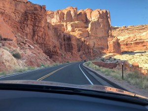 As you climb past the series of switch backs and begin your journey along the 18 mile, perfectly maintained road, you can immediately see signs for trail heads and viewing areas of the most popular sights. Yes, there are arches a plenty, but there are also other stunning geological formations, like “Park Avenue,” where it looks like you are walking down a street populated by towering skyscrapers. I highly recommend seeing the movie in the Visitor Center that explains how the landscape was formed. The entirety of the park is ephemeral in nature, and will change and ultimately erode over time. A long time, mind you; don’t feel you need to rush right out.
  Even in our time though, some of the arches have experienced massive rockfall, or have collapsed entirely. There are enormous rocks everywhere, impossibly balanced and held in place by the tiniest of foundations. Many look as though they could go at any moment. People are warned by signage all throughout the park not to walk on the arches. And though we didn’t see anyone being quite that stupid, we did see a whole lot of blatant disregard for the other signs saying to stay on the trails. I have a really hard time with rule breakers in the parks and had to bite my tongue a number of times.
 We got set up in a really awesome site in Devil’s Garden Campground some time in the late afternoon. It was in the upper 90s and promised to get even hotter during our stay. There are no hookups (ie. no AC), so we had to plan accordingly. For the most part, opening the back window and using multiple fans kept us reasonable. We turned down the fridge to its lowest setting, but even so, it struggled and sucked the battery lower and lower, even though we had full solar. I will just say right now we would not have stayed if we didn’t have the generator with us. At sunset, the battery could be upwards of 90% capacity, but then down all the way to 64% in the morning. We topped it up during approved generator hours (8-10am) and it maintained well during the day. It would not have recuperated from 64% however, and we would either have had to find a campground outside the park with hookups, or give up on cold milk for coffee and ice for my morning shake. That crosses the “fun” line for us, so we’re both happy to have caved and gotten the little Yamaha.
 We did a late afternoon hike right from the campground to Broken Arch and Tapestry Arch. Glorious. We happened to have timed our arrival back at the campground right as the sun was setting, so I got a sweet shot of Dory. Dinners were quick sauce pan reheats from frozen meals (like Beef & Broccoli, Pasta and Italian Sausage, that kind of thing), plus a bit of pre-washed salad or rice on the side. Not too much running of the stove and minimal cleanup.
 The next morning, Richard rode the National park road and I sagged him. That worked out perfectly for both of us because I got to be in the air conditioned car. We met up at the Visitor Center and he got changed. Dory had to come along with us because we only got to reserve the sweet site for one night. Then, we sort of meandered our way back, this time stopping at all of the lookouts and even taking some short hikes. Richard had to talk me into the short hike to Sand Dune Arch, and that one turned out to be one of my favorites.
  That afternoon, we hiked out to Landscape Arch, which included Pine Tree Arch, Tunnel Arch, Navajo Arch, and Partition Arch, as a bonus.
 Our third day in the park was the hottest and we strategized by taking a driving day trip down to Canyonlands National Park. I was REALLY ready for not hiking in the heat. Along the way, there is a breathtaking overlook at Dead Horse Canyon State Park. While the view is amazing, the story behind the name is awful. Apparently, back in the day, some cowboys corralled a bunch of wild mustangs out on the point of the mesa so they could choose which ones to domesticate. This resulted in the mass deaths of the rest of them, having been cut off from any water source. Humans suck sometimes. On a happier note, we checked out the campgrounds in the park. They are very nice and even have hookups and little shade shelters. That would be a nice place to stay if you’re going to hang out in Canyonlands for a while.
 The rest of the day we spent driving the scenic road through Canyonlands, trying hard not to hyperventilate when looking down from some of the view points. There is this one road, the “Shafer Trail” that looks pretty much like my worst nightmare. Incidentally, on our way in, the Acura navigation system had us routed a weird way. I honestly think Bruce was trying to get us on that road from down in Moab. Sorry honey, not with this driver. You can pretty much see all of the view points and even take the short trail to Mesa Arch in 3-4 hours. That was perfect. Dinner that night was in Moab at a place called 98 Center, and that was fabulous.
 Upon our return to Dory, we realized just how hot it had been because our real wax LED candles had completely deformed. One of them melted to the point that all of the electronics fell out of the bottom. Guess that’s not the best thing to have inside an aluminum trailer sitting in 100+ degree heat all day. Also: chocolate. Just nope.


