 Well, once again, we find that we’ve underestimated an entire area of the country. Beyond knowing Mt. Rushmore is in the Black Hills, I didn’t have much context. Richard had his sights set on something called “The Mickelson Trail,” which is a rails to trails, gravel bike path that runs over a hundred miles from Deadwood to Edgemont, South Dakota. That’s about all we knew and we got hit in the face with another unexpectedly rich region to explore.
 Leaving Badlands, we traveled west along highway 44. Tragically, this put us too far south to manage a stop at Wall Drug. So don’t ask if we saw Wall Drug. We did not. I’m pretty sure we’ll be able to move on with our lives despite this glaring omission, but we did see Carhenge later, so I think we’re even. The countryside along that highway is very beautiful. You skirt along the Badlands for a while until you eventually see the rise in the landscape on the horizon. The Black Hills are well named, based solely on their long distance impression. Up close, they remind me of the Sierra foothills. There are dense forests, outcropping of rock, and downright mountain grades on these roads. Somehow, my childhood memory of visiting Mt. Rushmore did not include mountains.
 One thing we did know going into the area was that we would be competing for campsites with the 500,000 motorcyclists coming through for the Sturgis rally. We had some hesitation over even trying for it, but found that there was one campground in Custer State Park, the Center Lake campground, that only took same day reservations. This was good news to us, as we knew we’d then stand an equal chance for reserving a site. One private place we’d called said that not only were they fully booked, but if they’d had a site open up, it would be an “event pricing” rate of $129/night with a 5 night minimum. Ouch. So we banked on Custer, went online prompty at 7am, and nabbed a site by the river for 3 nights. No problems, no worries.
 As we made our way toward Center Lake, we found that a) Custer State Park is really really big, and b) the roads in the park include incredibly tight tunnels and these things called “pigtails.” A pigtail is a place in the road that loops around itself like a winding staircase, passing over a bridge at the top. It’s a great way to gain elevation quickly, but would be problematic for a large rig or longer trailer than Dory. She made it through everything with no problem taking the Iron Mountain Road.
 I do not believe the same would be true if we tried the Needles Highway because there is one tunnel there that was a squeeze with just the car. We got set up in our site and went right to the Visitor Center to get our bearings a little. That is an impressive place, recently constructed, with interactive maps, movies, the whole deal. The big thing we had to work out was how to deal with the logistics of Richard riding the Mickelson trail.
We grabbed dinner in Custer and then went back to the site to process. There was more to do and figure out than we had bargained for. Custer SP approaches the level of a national park, plus, there are so many things to see in the surrounding area, it became difficult to prioritize. By morning, Richard had decided he wanted to go for it, doing as much of the Mickelson as he thought he could cover in a day.  With that said, it was a sixty mile drive up to Deadwood where I dropped him and his bike off at the trailhead and wished him well. I spent the following hours checking out Deadwood and Lead, and then headed back down to do some of the trickier state park roads. The “Needles” road is amazing.
  There are a couple of very tight tunnels, one whose width and height are just over 8 feet. The scenery is a glorious mixture of rocky and forested, with little meadows appearing here and there on your way. I shared the road with hundreds of bikers and found them to all be very well behaved. At some of the tunnels, where traffic started to back up, they were all eager to help direct traffic and get people in and out. I found that to be pretty cool. Despite the rhetoric on the various T-shirts and tattoos, they mostly seemed to be good guys (and gals), taking selfies and panorama shots with their iPhones, just like everyone else.
 I thought for a moment about throwing my kayak into Sylvan Lake, but it was way too crowded there, so I just moved on. By the afternoon, I’d done a lot of leisurely scenic driving and decided to head back up to the Crazy Horse Memorial. This turned out to be one of my favorite stops. I like the history of the monument, meaning it was initiated by a Native American named Standing Bear, in order to honor the history, culture and heroes of the Lakota people. The project is huge in scope and will take generations to complete. But the family carrying on the work seems to be very dedicated to seeing it through and maintaining the original purpose and intent of the sculptor. The project goes hand in hand with the creation of a university for native Americans, so overall, it has a very good vibe.
By around 4:30 I hadn’t heard from Richard and started to get a little worried. Thankfully, he checked in and was ok, but exhausted. It turns out riding on gravel is much more difficult than pavement (who knew?) and there were long stretches of trail that went through areas of abandoned little former railway towns, and no cell service. For a guy who is capable of covering a hundred miles in a day, he says the fifty miles he did on the Mickelson was harder. He got himself to the Crazy Horse Memorial road and exhaustedly changed and had dinner in the Visitor Center restaurant.
 The next day, Richard was pretty wiped out. We drove the Wildlife Loop in the state park and I got in a nice paddle on Center Lake in the afternoon. There I spied what looked like two Ospreys and a pair of Kingfishers. I took blurry photos. We ate dinner in swinging chairs, to the sound of the babbling river, that was apparently abnormally full. We felt ready to move on from Custer, but the park had a couple of parting gifts to offer.
 Before heading south, we stopped at the one and only dump station in the park. This remains a sore point for Richard. While he expected there to be a backup of RVs, he did not expect a backup of Bison. We got stalled for a bit, waiting for a small herd to pass. After that, we pulled in behind a large trailer and waited our turn. We generally take about ten minutes to do our business and the couple in front of us was doing a very thorough job. Eventually, the wife approached and suggested we pull around to use the other side of the dump. That was nice, we said, but it would take some maneuvering for us to come around so the hookups were on the right side. We asked how much longer they thought they’d be and we got a vague answer saying something about going home to Virginia. So we waited a little longer. Once we got it that they were going to be there for the long haul, we’d had enough and I commenced the round about maneuver to get us to the other side. Well, by the time we’d backed out and swung around, a huge RV jumped in front of us on the other side. Now Richard was mad and we had to sit there, watching Thorough Couple on the left, with Never RV’d Couple on the right, in a race to see who could take the longest. Wow, that was painful. Never RV’d guy was having an impossible time hooking up hoses, and since we were now irritated, I let Mr. Thorough try to help him. Finally, Thorough Couple started to put away their boxes and buckets and we got them to pull forward enough to let us through. I backed, pulled out, and swung around again so we could dump and go. I got out to help Mr. Never RV’d connect his hoses while Richard finished up and got set to use the dump hose to rinse out. Whether intentional or not (he swears it wasn’t), the hose jumped out of his hand due to intense water pressure and then proceeded to douse everyone standing outside, with me and Never RV’d guy taking the brunt of it. This could have ended in a fist fight, but instead, the guy laughed, acknowledged he’d jumped the line, and joked that spraying him was unnecessary. Richard still kinda thinks it was.
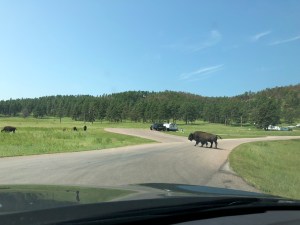
 After that, we headed out of the park, taking the long route via the Wilderness Loop. As Custer State Park’s little wave goodbye, we got the incredible treat of getting caught in a Buffalo filled traffic jam. There must have been a hundred crossing the road right in front of us. It was beautiful, exciting, and scary all at the same time. There were no incidents or aggressive moves at all in the herd, but any stupid move from the humans in the crowd could have proved dangerous.
 We drove out and moved on, having chalked up sightings of Pronghorns, Donkeys, Prairie Dogs, Deer, Ospreys and Kingfishers, in addition to a whole lot of Bison up close, plus Mt. Rushmore in the distance. This is an amazing state park, but we suggest you think of it more like a national park, and be prepared to spend a lot of time in this area.
Total miles from Badlands: 109.6, 15.6 mpg, 3 hours 14 min. Center Lake campground, site 32. Easy walk to the lake. Vault toilets with running water and shower rooms by the lake. NO cell service at the site, but we were able to hit ATT from the water and use the booster for 1-2 bars of slow Verizon LTE. Shady sites, but we got some solar at midday. Nice peaceful campground.
 This was our day of postponement. We are resisting the drive across the flats and heat, so instead, we made it a short travel day and threw in some shopping and city sight seeing. We also got a really lazy late start, pulling out around noon. Richard biked the road around the reservoir, a short but happy ride, and certainly preferable to trying to ride 80 (pretty sure you’re not allowed to anyway).
 Quickly following that, we found an upscale shopping center in the heart of ski resort-ville just above SLC. There we faced a small crisis of identity, as we needed to choose between shopping at Whole Foods vs. Walmart. At home, we are Trader Joe’s people except for specialty items. Then it’s Whole Paycheck for whatever we can’t find at the independent health food store. Normally we spend about the same amount for those couple of items as we’ve spent for the rest of the week’s groceries. While traveling, I openly admit that we are people of Walmart. Thing is, we can find exactly what we need, in almost exactly the same store layout, whether we’re in Utah, New York, or Ontario. It’s really really easy to walk in and buy milk, frozen skillet dinners, and maybe some lithium grease and a pair of pants. And anyway, we tried to park in the WF lot, but they didn’t have nearly enough double parking spaces for RVs, so we took our low brow business over to Walmart, where there was lots of parking and at least four huge RVs camped out on the periphery. What better way to follow shopping at Walmart? Pulling into a KOA of course. The Salt Lake City KOA is HUGE. But still exactly like a KOA. Ah, we’re in our element.
 For the rest of the afternoon, we did an impressively good job entertaining ourselves by checking out the Utah Natural History Museum. Wowie, this place is very fun! The design and architecture of the building is just beautiful, and the exhibits are high tech and interactive. One of the themes of this trip has been learning about the Laramide Erogeny, the millions of years ago crash between two tectonic plates.
  The museum had lots of nicely laid out displays showing the dynamics at work and how this event created the landscapes of the western U.S. For example, because a huge part of the middle of North America was an ocean during the Cretaceous period, there are not many land based dinosaur fossils found there. It’s in the Utah and Colorado regions where the conditions were not only right for them to have lived there, but also for the fossils to be exposed due to the erosion of the pushed-up layers of rock.
  Anyway, the museum in SLC had lots of huge and complete skeletons on display and that was pretty cool. There were other fun exhibits to explore, plus we saw the solar array at the top of the building. Now that would power a 12v fridge for sure. Might be hard to mount on Dory’s roof though.


 We exited Wyoming today with no great fanfare and entered Utah. I suppose you could count Little America as some fanfare, though a stretch to call it great. We did have the soft serve ice cream for 75 cents, so that’s something. The only other notable event of the drive was the observation that Utah rest stops seem far less desolate than the ones in Wyoming.
 We again were able to find a pretty nice place not too far off the highway in the form of Rockport State Park. This is on the stretch of 80 just before it winds down through the mountains into Salt Lake City. Rockport Reservoir is visible from the road, but the state park entrance is all the way at the bottom.
 We’d called in the morning and were told there were still lots of sites free, including a couple with partial hookups. So we set that as our target and traveled an easy 278 miles to arrive in the afternoon. The water level is noticeably low, like something out of the California drought playbook. We heard the level was at 61% and that made getting to the water a bit trickier than I wanted to manage with the kayak. Still, we had a nice view, and AC, so all was fine and dandy.


 The things you find when dumping! Or when going off the road a bit. We made tracks along 80 today, but managed to spice it up with a meander, a historic site, and a BLM running Beaver TV.
 Richard rode his bike out of Curt Gowdy and followed highway 210 through the Medicine Bow National Forest until it got back to Interstate 80. He certainly got his fill of climbing on this lovely route, and actually ended up at the highest point on the highway. How many times I’ve stopped at the Lincoln Memorial on 80, I have no idea. I know I’ve never approached it from the back though, so that was new. We met up at the rest stop and Richard got changed into “civvies” for the continued journey in the car.
 We knew we’d need to dump tanks somewhere and the person at the Curt Gowdy Visitor Center recommended we dump at “the prison.” Well of course we were going to have to do that, weren’t we? It was a quick drive to Laramie, WY, where we followed directions to the Wyoming Territorial Prison State Historic Park. Wow! This is a really interesting place to stop, especially if you take the self guided tour and run into a park service volunteer who really knows her stuff! Turns out this was the only prison to ever successfully incarcerate Butch Cassidy. They have a very detailed and well presented display on him in one of the cell block areas.
  They also have a cool scavenger hunt thing where they give you a card with a prisoner’s information and you search to find the poster that outlines their story. We got Alison Cunningham, a man who appears to have taken the fall for an abused wife in the murder of her husband. He served 13 years. There is also an exhibit for the women’s cell block. Plus, throw in some well preserved period buildings and a display on period ranch life and you’ve got yourself one fascinating dump stop.
 It was a peaceful, remote feeling place. Pronghorns grazed in the arid prairies along the approach, and the sheltered little valley by the river offered one of the few patches of blue sky within the widespread smoky haze of the interstate. The only downside to the place was the abundance of mosquitoes. I donned my Permathrin treated clothing and braved it.
 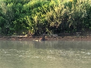 I was rewarded with a beaver sighting across the river. In fact, as I watched the wildlife show, another one appeared from the branchy lodge and made its way up onto the bank. This was extremely entertaining and I watched them for a long time as they swam, emerged onto banks, grabbed branches off the bushes, and brought them back to chew on in the water.
 The sun set and flocks of Pelicans whizzed by in formation, disappearing into the next valley down river. What a very nice place.


 We began the day with a very large frog hopping around under Dory and ended the day with geese and a bunny hanging around our site. We’re taking the slow, scenic path home, using Interstate 80 as our guide, but finding ways to veer off at anything interesting.


 I’m going to put in a serious plug here for Scottsbluff, NE. I know we make this a “must do” destination to see family, but there is actually some really interesting history here and a national monument to boot.
 Before we get to that though, Carhenge. Yes, we made a slight detour in order to stop at this place. Google rates it a 4.7, as compared to 1880s town, which got a 4.6. I’m not sure I could say it’s “worth it,” but the theme of the place seems to be more about “why not?” In fact, the very first informational plaque you see begins by saying: “Your first question upon encountering Carhenge might be Why? But creator Jim Reinders’ answer would simply be Why not?” So there you go. Plus, it’s free. It might come down to how much gas you’d need to use to go out of your way to get there in order to determine whether it’s worth it for you.
 Also along our way, and actually where we stopped for lunch before going to Carhenge, was Chadron State Park. That was a very nice place with lots of picnic spots and tons of outdoor activities, like archery ranges, swimming pools, trails, and playgrounds for kids. We took advantage of their nice dump facilities and they didn’t even charge us for it.
 Arriving in Gering, we stayed again at the Robidoux RV Park and that really is a nice hookup spot. Clean bathrooms, space between sites, kinda WiFi, and views of the bluff. Bonus for us that it’s three blocks from my aunt and uncle. We even biked over there. My aunt served us a wonderful home cooked meal on Friday. We rate their place a 5.0, but you’d have to check to see if she’s willing to invite you over. 🙂
 Saturday morning, Richard went to bike around the monument while I tried to catch up on blog posts. Dear WordPress, you really really need to figure out how to support offline blogging. This has been a source of frustration for me this whole trip. But I digress… There is a Visitor Center at the foot of the bluff that explains how this landmark was very important for early homesteaders, as it marked the end to the long journey across the plains, and the warning of impending mountains. Early settlers went right through Scottsbluff on the Oregon Trail and you can still see the ruts of the wagon train wheels in the ground. The monument itself is named after some guy, Hiram Scott, who died in the vicinity of the bluff, in 1828. So they named it after him. Kind of an inglorious way to get a name, but the distinctive and abrupt landmarks of this area were a welcome sight to weary travelers.
 Following important chores like laundry and shopping, we both went back out and explored the new “Legacy of the Plains Museum.” This is well worth a visit! It is a nicely laid out exhibit, with lots of movies and touch screen or audio tour narrations. We spent over an hour there and didn’t see everything.
  We came away with a solid feel for heartland life, both past and present, native and pioneer. For me, it was nice to fill in some gaps in my historical understanding of the place. I came away feeling connected to and proud of my Nebraska heritage.
 We left in no great hurry on Sunday, openly reluctant to depart. We’re both feeling melancholy as we trudge steadily back home. We know our summer trip is not quite over yet, but we feel the tide a-turning and the close to summer approaching. It was also really nice to visit with my aunt and uncle, something that is not easily accomplished from California. Sigh.


 This was a one night stopover on our way south out of the Black Hills. We had no trouble getting a walk in site at the first come first served campground. After dropping off Dory, we went over to the Visitor Center and signed up for a cave tour.
 We opted for the max package, called “Fairgrounds.” The remarkable feature in these caves is something called “Box Work.” There are no stalactites or stalagmites in this system because it is a dry cave formation, so no dripping water to carry minerals through the rock. The Box Work is the result of cracks having formed and filled with calcite way before the actual caves had opened up.
  Some of the openings were created by steam slowly eating away at the rock, some by the dissolving of the surrounding limestone due to acidic seeping water. What remains is a truly beautiful crisscross patchwork of delicate calcite. The sides of the walls glisten with “cave popcorn” and little embedded geodes. It is well worth the 450 steps it takes to witness it. There are shorter tours with fewer stairs too.
 We then headed up to a lookout trail, because why not do some climbing after going up and down a whole bunch of stairs? I’ll admit that the view was worth it, plus, we got really strong LTE at the top and Richard was able to make a belated birthday call to his mom from the top.
 We experimented with some shading in the afternoon. First, we put up a sheet of Aluminet on our new port side keder rail. The purpose of this is to reflect light away from the outside wall on the refrigerator side so that the fridge does not suck up all the battery power as it’s trying to cool. This seemed to cut down on heat, but we can’t really be sure. We also put up a visor on the door side to see how that would work just for shade. The first thing we realized was that our poles seem to be missing something. We got the visor from an Altoiste who’d never used it, so we’re not totally sure we have all the pieces.
  I butter knifed a solution by putting rubber bands on the inner poles so they’d stay up. I also didn’t put on the small keder rail pieces at the bottom that are supposed to secure the guy lines. We had bets on whether it would still be up after we came back from the cave tour and hike, but it was standing! Unfortunately, by morning it had come completely off and the poles were lying on the ground. Not a fair test, to be sure, and our chairs had also blown over, so there must have been some good wind. I’ll call Pahaque to see what I need for the poles and try again with the bottom keder in place. I liked it for shade and it is certainly easier than the awning. Plus, it does not obscure the view. No bug netting, but you know, get over it. The quest continues…


 I’ll be honest, I wasn’t as excited as Richard about coming to Badlands National Park. It’s not that I knew anything about it, I just imagined it being sort of overall brown, I guess. After three days here, I will absolutely recommend this park as one of my favorites. And no, it’s definitely more than just brown.
 Getting here meant a slog down highway 90 toward the west. We broke up the miles with two stops: Mitchell, and 1880s Town. In Mitchell, we re-stocked groceries and Richard went to a local bike store to get his handlebar tape redone. They seemed to be undergoing a full rehaul of most of their roads. As such, our drive by of the “Corn Palace” did not result in an actual visit because we didn’t want to figure out how to park.
 The stop at 1880s town was what I would deem “worth it.” It was very well advertised via billboards and I guess my expectations were pretty low. But actually, the place boasts an impressive collection of actual buildings and antiques from the late 1800s to around 1920. Some of the items were actual set props from such films as “Dances With Wolves,” and they are obviously very proud of that. It was a fun break from the road and worth the $12 entry fee to stretch one’s legs in an old timey restored town.
 Easily the most entertaining leg stretch happened at a rest stop where a truck we’d been following pulled over. In fact, I had steadfastly resisted the urge to drive faster than prudent in order to get a picture of the tanker. When the driver got out, we had to ask, “Ok, so what’s in there?” He laughed and told us he gets some funny reactions since the company started putting these ads on some of the tankers.
  He also told us a funny story about a bus full of tourists from England. As he was pumping diesel into the ground, a man came up to him and whispered, “Just go along with me here.” A few minutes later, he was assuring the man’s wife that yes, indeed, it was coffee he was pumping into the ground because, you know, Americans drink A LOT of coffee. He saw the couple later boarding the bus, the woman soundly hitting her husband on the head with her purse.
 Once we arrived in the National Park, we drove down the park road to the Cedar Pass Campground. One expects national park roads to be spectacular and this one did not disappoint. Right away, I could tell I’d undersold the place in my mind. We got in two little hikes after setting up Dory and driving back to the “Door” and “Window” trail heads.
  Then it was back for dinner and relaxation time in Dory as it gently rained outside. Right in the middle of our chilling, I leapt up and ran outside, probably shrieking, “Oh my God!” Or something to that effect. The clouds had parted and a full double rainbow filled the sky. It was still drizzling a little, but everyone in the campground emerged from whatever shelter they had in order to photograph the spectacle. I don’t know whether it was more fun to witness the vibrant colors, or hear the general sounds of laughter and amazement from our fellow campers.


 The next morning, we attended a ranger led walk to further learn about all things geological. Since I barely understood it all, I won’t try to regurgitate much information. But, I’ll list of couple of main points. This area represents the easternmost expression of what happened when an oceanic plate slipped underneath a continental plate and created all of the major national parks in the western U.S. Erosion is the big deal in Badlands. Once the particular mix of minerals in these rocks became vulnerable to erosion, the process began to happen very quickly. The natural erosion rate here is about an inch per year and the entire formation will be gone in 500,000 years. Another interesting point was that part of the make up of the rocks includes elements that absorb water and expand to 20 times their size. This results in a continuous cycle of cracking, flaking, and sloughing of surface material.
  As underlying layers are revealed, you can see distinctly colored bands of rock, varying in hue depending on what was happening geologically during the time the sediment was deposited. For example, the yellows in the “Yellow Mounds” get their color from a period when the entire area was a richly vegetated, swampy marshland. Fascinating stuff and we were thankful to be led by a park ranger whose primary area of study is geology. As a bonus, we spotted a herd of about ten Bighorn Sheep males near the parking area, which the ranger said was highly unusual in terms of numbers hanging out together.
 Later we went on a hike along the “Medicine Loop Trail” and looped back on the “Castle Trail.” All told, this was a bit over four miles and began with a long flat stroll through grasslands. There were many clusters of plants, like wild roses, lavender, and little sunflowers, to enjoy along the way. We nearly, but didn’t, step on a snake in the path. The return trail took us right through the rock formations, offering really nice views of the eastern wall.
  Before we got back to the car, we ran into two guys who were obviously up to something scientific because they were carrying cool gear. Turns out they work for the park service as students and were assisting in tagging and tracking the population of Bighorn Sheep. They knew from collar and sensor data that one of the ewes had given birth and they were out checking on the calf. Using their tracking tools, they were in fact able to hone in on the general direction, and lo and behold! They appeared atop a distant rock, calf clearly healthy and grazing with mom. Talking to them was pretty cool and we learned about some of the ins and outs of managing wildlife in a national park.
 Later in the day, Richard wanted to try something called the “Notch Trail.” I predicted from the description that this would not be something I would enjoy, but agreed to go as far as I felt comfortable. The brochure stated that there would be a steep ladder in the middle of the trail and that there would be sections on a ledge with steep dropoffs.
 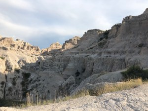 But ok, I went as far as the ladder, thinking I’d tap out there. I don’t know what I was thinking, but it didn’t look too bad to me from below. I climbed the ladder like a badass hiker and it wasn’t until the last five feet at the top that I thought, “I have made a terrible mistake.”
  At that point, I felt irretrievably committed and hoisted myself to the top. I knew full well that if I turned around to look behind me, someone would need to call for a helicopter rescue. So I kicked into self calming high gear and stared really intently at the rock wall. Richard continued on and I ventured out a little bit. When I reached the point on the ledgey part of the trail where I was pretty sure I’d lose it, I decided to just hang out at the top, mustering the courage to go back down the ladder. The fact that I kept myself from totally freaking out is something of a major feat. I think the thing though that got me down that sucker was the little kid who kept repeating, “I am brave and strong and I can do this.” I probably owe that kid my life cause I made it down using the very same mantra. My right thigh still hurts in this very specific spot, because apparently, that is the ladder descending muscle.
 Our last full day in the park was set aside for Richard to ride the national park road while I drove it. Wowie, what a road it is! Of the distinct “lands” we passed through, I’d have a hard time choosing whether my favorite was Yellow Mound Land, or Prarie Dog Land. We even got to experience Lightning Land in the form of a passing thunder storm and what was very cool about that was how the colors of the rock change with the light and rain. It was one of the most beautiful things I’ve seen, and I can say I’ve seen some stuff. Wrapping up our stay, we got to catch a stunner of a sunset during a break in the thunder storms.


 … and sometimes you stay here. This is all part of the journeying and it was planned primarily to do laundry. And, as Altoistes say, there is no bad site in an Alto. We can close privacy curtains and have no idea where we are, or who is staring at us really close in the next site. Plus, hey! We’re right next to a Camping World and a gigantic U.S. flag. All good.
 During the day, we traversed the southern border of Wisconsin and just crossed over into South Dakota before calling it a day. The countryside is a departure from the land of many lakes and is steadily transforming into solid farmland and open plains. We’d have gotten a shot of the ‘Welcome to South Dakota’ sign, except we received a spam phone call (more on spam later) right at the moment Richard was trying to take the picture. He called back, just to complain, and for some reason was passed to the voice mail for the Chinese Consulate of San Franscisco. If they need us for important international business, they’d better time their calls better in the future! Arf.
 The hands down highlight of the day, however, was our visit to the SPAM museum in Austin, Minnesota. I’m am at something of a loss for how to capture this experience. I was certainly impressed by the sheer number of interactive exhibits. And not only do I now know the backstory of how the name came to be, but I also know that I am 20 SPAM cans tall. I think my favorite display was the “Monty Python” routine set to endlessly loop on a screen, proudly mounted atop a shelf made of SPAM cans, in all their glorious and variable flavor options. Sorry, we neither tasted nor purchased samples.


 Sometimes a spur of the moment, “Hey let’s try that place,” turns out to be one of your favorite stops. We had miles to cover and a pit stop for Bruce planned along the way, so we were looking at three possibilities for overnights, each about 50 miles apart. This park won based solely on mileage and it was just lovely.
 But first, we had to take care of an expected oil change. Just like our last cross country trip, we knew we’d need to find an Acura service center somewhere along our return route and Bergstrom Acura, in Appleton, Wisconsin, timed perfectly with the oil level hitting 20%. They had a hard time understanding our situation at first when we called, and kept trying to push us to a scheduled appointment several days out. Once we got a manager on the phone and explained we were traveling across the country, they got it and were ready for us when we pulled in.
  As Bruce was getting his makeover, we got to enjoy really fast WiFi. The oil change turned into more regular maintenance work that was due, and two new tires. The service person (whose name was Alisha who has a car named Dory) was super friendly and probably surprised at how nonchalant we were at paying a LOT more money than an oil change. Thing is, we were thrilled someone took a close look at the tires and we are always happy to pay more at a planned service stop than, say, out in the middle of nowhere. So her look of quasi nervousness explaining we’d probably be ok if we kept going as is, changed fast to a look of relief when we were like, “Oh yeah, do the service, And new tires for sure!” She got Bruce a nice wash and gave us a $1000 Acura tote bag. Bruce looked fantastic for about ten minutes on the road.
 We clocked 267 miles by the end of the day, so I was pretty happy to stop at the Mississippi River. The state park was just three miles off the highway and looked to have availability when we checked online. There were no electric hookups, but we decided that was fine based on temperatures in the 70s. The approach to the campground is about a mile of gravel, but it is well graded and hard packed. The campground itself is situated on bluffs about 600 feet above the river, in a densely wooded, tropical seeming, forest. There are about thirty sites and we got one at the end of the loop. It was completely private and right next to a couple of hiking trails.


