 This was our very last one-night stop for the summer. *sigh* Our theme for this trip was to avoid the scorching heat. Mission status: nailed it! In fact, we nailed it so much, we got a little wistful for some higher temps and a little less moisture. I mean, we were running the heater in JULY and had a hard time drying out towels for a good portion of this trip. Anyway, we got our wish on our last day, not so much as to be miserable, but just enough to send us looking for some cool river water.
 Leaving Patrick’s Point, we were still in a fog, literally. Richard chose to bike out of the campground and we met up about ten miles south, at Clam Beach. He said the Scenic Drive south of Trinidad may have been scenic, but also was practically nonexistent in some sections. He hit four stretches of gravel and said the road seemed to be falling off in a couple spots. Glad to have taken Dory down 101 instead. Clam Beach was muggy more than foggy, and definitely warmer. Heading further south and inland along 101 cleared the humidity and brought on the summertime temps. Finally, our towels got to dry out. Just in time for our last night.
 Standish Hickey is a smallish campground just outside of Leggett. There are one or two areas on the highway between Fortuna and Leggett that get much more narrow and twisty than one would expect of a major California highway. It was nothing Dory couldn’t navigate, and nothing scary, despite the yellow warning signs. Entering the campground is another matter if you’re trying to get down to the river. While trailers and RVs fit into many of the sites in the upper loops, you are not allowed to camp down in the Redwood Campground with a trailer. This is a legit good rule. Getting down there requires going on a very steep and narrow road with a 180 turn at the bottom. Then the pavement ends and you get to go over a “seasonal” bridge. Not sure exactly what that term means, but it doesn’t inspire confidence when traversing with a car.
 It was hot enough for us that we drove it anyway, not wanting to walk our butts down there and back up. The South fork of the Eel River is very calm and shallow at this location. It makes for a lovely place to take a dip in the water and calmly float around. Lucky we’d been dragging a floatie around with us several thousand miles that hadn’t been used since our last stay at Shaver Lake. It was way easier inflating the floatie than it would have been to set up my kayak. So we just played around in the water.
 There are tiny little fish who will come right up to your feet and lick them (or whatever fish do with their mouths). That was pretty fun. I’ll have to do some research on whether there are places where you can do “tubing” (apparently the correct term for what I’ve been calling a floaty boaty). I’d really like to do a whole lot more of that. Not having enough information on this stretch of the river, it wasn’t going to happen this time. Just getting in the river was delightful and a perfect way to cool off.
There were tons of bike tourers staying in the campground and it reminded us of our past trip. It also reinforced how much more we like camping in Dory. But we had to have done it in order to know. We feel that by suffering through that, we’ve earned the right to sleep on 2 inch thick organic wool topped cushions, with indoor plumbing and big screen projection movies. After dinner, we walked across 101 to the Peg House, where they serve grilled food. They also sell “world famous” blackberry sundaes, and we partook happily. Then it was beddy-bye time for the last time before returning home.
 It was a great trip. We really preferred staying in places for more than one night. Three nights was a nice amount of time in most places. We spent the vast majority of the time without electric hookups and that worked because we weren’t in the heat. It’s really good to have the generator because you definitely cannot count on the solar panels keeping you topped up, especially in the redwoods. Even blogging was easier this trip and I think that’s mostly because we weren’t moving so much. I maxed my ATT data plan but it still seems to be cheaper paying for additional gigs than it would be to upgrade to a full on unlimited plan year round. We also got our credit cards compromised and cancelled again. That seems to be a thing that happens when we travel.
 Our geological theme this year was volcanos, and that was really cool. We visited six national parks and put a whole bunch of state park pins on the map. Cooking worked really well and I’ll be following up with a specific post on that. Mostly though, this was a really cool experience in that we got to go exploring off the I-5 stretch. We saw amazing things we never knew were there, but have passed by countless times. We towed on the order of 3,552 inefficiently planned miles, with one tune up along the way for Bruce. It was awesome hooking up with our BFF camping bud and her pack, meeting friends (new and not so new) on the road, reconnecting with lifelong friends, and even more awesome to get to spend two solid months of time with my sweetie in our Dory. These are the days.
Total miles from Patrick’s Point: 117.5, 14.7 mpg, 3 hours, 3 min. Site 16. No hookups, no dump, no solar. Nice bathrooms. No cell service, but free wifi across the street at Peg House. Definite road noise from 101 in the Rock Creek Campground.


 Stairs. That’s my big picture overview of this park. So many stairs. I guess that’s what you get when you’re on a cliffy point overlooking the ocean. And I suppose I could have just overlooked, rather than going all the way down to the beach, or all the way up to the lookout points. But… the views! So, yeah, I got my stair stepping in for the month.
 We backtracked from Grizzly Creek up north to Patrick’s Point and arrived after a quick stop at a private RV park to dump tanks and fill with fresh water. We knew we’d be in shade for three days, having come out of shade for three days, and would likely need to run the generator. Plus, we decided to do a Caravan Mover Maneuver to situate in the site, and that drains the battery something fierce. Again we found our site to be better suited to a van or motor home, with the hanging out area placed on the right. This time we wanted to use the grill and facilitate outdoor cooking, so we spun Dory 180 degrees. It took a while to avoid both roots and posts, and would have been easier if we’d spun her in the loop road before entering the site. We got her in eventually though and started up the generator. I used the time to catch up on blog writing, if not uploading, and Richard scoped out the local bike routes.
 We took in a nice sunset from Patrick’s Point and discovered that most of the trails at the coast either go steep steep down to the beach, or steep steep up to a rocky point, or both. Once such is named “Wedding Rock” and we saw a family all gussied up to take photos out there as the sun set. That one involved not only the drop from the cliff to the shore, but then a narrow stairs climb up to the cliffy selfie spot. I was content to catch the view from back on solid footing, behind a guard rail.
 The next day Richard had to get some work done, and we both started feeling the angst coming on as our journey was wrapping up. To shake it off, we ventured over to Trinidad after lunch. There’s a beautiful beach there, plus a trail that I thought would take us up to a lighthouse. I don’t know much about lighthouses it seems. I thought it would be located up high, you know, to light things. But apparently it was sort of hidden from view, past a locked gate, down closer to the water’s edge. But no matter, because lighthouses are not something we’ve chosen to be that interested in, and the trail provided some stunning scenic shots up at the top anyway. If we ever decide to love lighthouses, I guess we’ll have to go back on the first Saturday of the month, between 10 and 2. There’s a replica in the parking area of the beach, with the original bell too, and we were both fine with that.
 This part of the coast is so lush with plant life, many of the seaside trails give you no indication you’re right above the ocean. It’s not until someone has come along to carve away the vegetation in order to make viewing windows that you even see water. I’m going to say that’s a bonus, because without the plant life, many of those trails would have been extremely deathy. Instead, it was a steep climb, but through pretty plants, with a view at the top.
 For our evening entertainment, we rode our bikes out to Palmer’s Point and descended three flights of steps down to the tide pools. We’d missed the low tide by an hour or so, but we still saw some starfish, crabs, and all kinds of anemones. It was quite overcast and I wasn’t sure I was going to get a sunset, but the bright orange ball managed to punch through the cloud line, just at the last few minutes of the day. The results were quite spectacular and made the climbing back up somewhat more palatable. The last of the “stairs” are constructed in the same way as the Ladder of Terror from
 On our final day in the park, we walked the interior trails. The first stop was to check out


 This point in the journey really had a lot to do with road conditions. Getting there from Etna was not as straightforward as our dueling navigation systems suggested. We find that Acura is not to be trusted completely when it comes to routes because it has directed us toward narrow, dirt roads on plenty of occasions. But even Google wanted to take us on Highway 36 along a stretch that had yellow warning signs posted, saying specifically not to do that with a trailer. Heck, even the ‘how to get here’ blurb from the State Park website said in no uncertain terms not to take 36 coming from the East. So we asked around about Highway 299 and got reassurances from people with bigger trailers than ours that 299 was fine. Those are always the people to ask.
 I was gearing myself up for a long, strenuous day of towing in the mountains, but ended up being pleasantly surprised, which sort of mimicked our 15 years ago bike trip through these parts. Highway 3 from Etna to Weaverville was twisty and narrow, but also had very little traffic so I could go slowly. There were guard rails in places where I wanted them, and there was never any worry about whether oncoming traffic would take us out. And it’s a totally beautiful section of California. I could easily see making a trek to Trinity Lake for an extended stay and being quite pleased.
 We passed through the quaint little town of Weaverville before heading east on Highway 299, and spent the next many miles watching river rafters floating down the Trinity River. We only got stuck once by road construction, which more closely resembled mountain side destruction. I guess you have to cause the landslides to prevent the landslides?
 299 gives you a good climb out of the coastal range, but totally fine for Bruce towing Dory. I do remember riding that particular section on a bike. Richard remembers that too. Mostly, we both still have the image of me getting to the top of the first climb and bursting into tears because that was only the first one of the day. I cried, miserably chewed some cookies, and somehow got to the summit of the next climb way before I expected. Then it was time for happy tears and a long, long descent into Arcata. Know what? Cars are awesome.
 Once across the top, cell service came back, along with gas stations and grocery stores. We did some provisioning and headed out to the campground, arriving easily by 5. Not so bad. I had to reserve two different sites in order to achieve a three night stay. We left everything hitched up, knowing we’d be moving two spots over the next day. I’ll note that both sites were designated for “motor homes” and thus, the picnic table and fire rings were on the wrong side of Dory. There was plenty of room between us and our neighbors, plus room at the back, so it didn’t really matter. Just something to note.
 The campground is really nice, with one exception: road noise. People take Highway 36 very fast. They even honk at campers when they slow down to turn into the campground. The single loop is right by the road and we could hear cars whooshing along any time we were hanging around in the site. Otherwise, it’s got lots of shade, a river to play in, and some pretty hiking trails to explore. We did all of the trails (maybe 5 miles total?) in one day. It’s your standard old growth redwood forest, so very lush and very beautiful. There’s also lots of poison oak to dodge.
 The next day, we had this great idea to go explore the “
 We’re talking sustained grades of at least 12-15%. And then he’d hit gravel sections, cattle grates, steep descents over nonstop potholes, it was crazy. I stayed as close as I could to SAG, but the road was so narrow, I had a hard time finding places I could safely pull over to wait. At this one killer part, I don’t even know how steep it was, 20%??, I was able to stop and wait. And wait, and wait. I started to worry when I saw the poor guy straddle walking his bike up an insane incline. I talked him into putting his bike in the car, just until the ultra steep section had calmed down a little. I then let him out at a ridge and he continued on for a while. Until the third gravel section, this time going down at maybe 18%. That was enough for him and we continued the rest of the way in the car.
 Holy cow, there’s a reason this coast is “lost.” Insanely beautiful? Absolutely. But not at all a minor thing to reach. At least I wasn’t towing. Crazily, we were passed many times by trucks, like actual big trucks, some with trailers, hauling who knows what. I get it that they’re used to the roads, but one of them would probably have taken off my towing mirror if I hadn’t removed it first. Anyway, it was well worth the drive out, just to see, but I’m pretty happy not to have blown a tire, even going super slow.
 After that, we got dinner at a great place in
 Yes, we looked for Ewoks, but saw none. Yes, I was tempted to have us both put on our bike helmets and make “Zzzzzzzhhhhh” sounds while doing the short loop trail. I resisted the urge, but imagined it fully.


 Well that did not go as planned, but that’s traveling for you! We had intended to punctuate our crossover toward the coast with a two-night stop in the Klamath National Forest area for a nice bike ride. Everything was going as planned until around dinner time after we got there. We walked in to a restaurant in Etna, noting the sky seemed a little hazy. “Is that smoke?” we wondered aloud. Nah. An hour or so later and, as we came back outside, the smell and orangish tint in the air left no room for wishful thinking. By the next morning, the air quality was such that we really didn’t even want to go outside.
 So, that made us do a full about face and just sort of hang around doing laundry and getting things done online. It was not like a disaster or anything, and we got a nice drive in from Lava Beds, catching a cool photo op of Shasta along the way. There were a couple of different bike rides Richard had researched, one going 60 miles around the Etna/Fort Jones valley, and the other going up to the summit of Sawyer’s Bar Road. Some day we’ll have to go back when Oregon is not on fire so he can try those out.
 As for Etna, I really liked it. It’s a very cute little town with a plenty of history and just enough amenities to feel like an oasis. In fact, if you’re hiking on the Pacific Crest Trail, Etna is the lifeline in a hundred miles of wilderness stretching in either direction. Hikers walk a full ten miles out of their way to make it a provisioning stop. All we had to do was run the air conditioner and stay out of the smoke.
 One extremely cool thing that happened came about because Richard has no impulse control whatsoever. After dinner, we went walking around the single street that makes up “downtown.” There was a hand drawn map posted outside, clearly showing there was a bike shop right there. But the building seemed to have all of its windows covered with paper, like it was either out of business, or doing a remodel or something. It did not look like a storefront where the general public could just walk in. There were no signs indicating what it was, but careful peering revealed some kind of bicycle based activity going on inside. It was simply too intriguing, and because there were no signs explicitly saying “DO NOT TRY TO OPEN THIS DOOR,” Richard gave the knob a try. What he found on the other side of that door was one of the
 Steve Potts
 Besides that, we had a lovely dinner at


 Another National Monument, probably the last for this summer, is in the books. Lava Beds is one of the lesser known of the National Parks Service territories, but it comes in as Richard’s favorite from this trip. It boasts the impressive statistic of being home to over 700 volcanically created caves and lava tubes. We were able to find a place in the first come, first serve campground and explored a total of seven different caves, plus a couple of hikes.
 We took the now very familiar Highway 97 down toward the border between CA and OR. From there, it’s a relatively short drive directly down south to get to the kiosk at the northern entrance. We were asked about “
 Richard rode from the kiosk to the campground and we were able to see some of the large areas of ancient lava flow along the way. Our hope was to find a site that had some afternoon shade because temperature highs were in the low 90s that day. We were pleased with what we got and were not in danger of finding ourselves without a place to stay. There were people there, but still enough sites that we got to choose one we liked.
 After getting set up, we went to the Visitor Center to check things out. There we got a map and some recommendations for good caves to see. Note that some caves get closed at times when there are baby bats present, and I think there were four we could not go inside. We started by driving the “Cave Loop” road and stopped at our first lava tube: Golden Dome. We found the directions and description in the park brochure to be inadequate and we were confused as to which way to go once we descended the steep ladder. But, since one way would require low squatting and/or crawling, while the other way did not, it was an obvious choice. That particular cave has a figure 8 pathway through the tubes, so you do have to be kind of careful about how you go. It was super cool, but maybe we should have built confidence doing an easier cave first.
 Our next stop was Sunshine and that was easier to navigate. Plus, as its name suggests, there are rays of sun coming through occasional roof openings, so it’s not as pitch black as the others. Back at the Visitor Center is one called Mushpot. That one is lit, and has a paved path, plus informational kiosks along the way. This is a great intro and gives you context as you explore other caves.
 Normally, lava tubes are very rough on the floor. You can really picture the lava flowing through and then hardening. Sometimes it presents with a smooth
 The next day we began with a ranger led tour of something called the “Fleener Chimneys.” These are a group of three lava chimneys that sort of spit out the lava in splurts and gurgles. You can see way down deep into one of them, and apparently, these three little mounds were responsible for depositing flow material for a solid mile downhill.
 After that, we climbed the one cinder cone that you’re allowed to walk on. There’s a ranger lookout station up there and it provides really cool views of Shasta and the surrounding landscape. It’s much easier to actually see the flow patterns from up there. It’s a climb, but worth it, and we did it before the heat took over.
 And where do you want to be when it’s over 90 degrees? In a bunch of sweet, 50 degree caves of course. We spent the remainder of the day walking around in the Merrill Ice Cave, the Valentine Cave, and the Heppe Cave at sunset. In between, we signed up for another ranger led tour, this time going through the Sentinel Cave. I highly recommend taking ranger led tours. You just learn all kinds of cool stuff. Like, for example, there is this glistening stuff on the walls that is either silver or gold and looks like you’ve struck gemstones. It is actually a specific bacteria that is feeding off the minerals in the tiny water droplets. Valentine Cave had a ton of the stuff.
 They also explain things to you, sometimes over and over, about how the things actually formed. Simplistically stated, the lava flowed downhill, formed a crust at the top where it cooled, allowing the hot stuff to keep flowing underneath until it formed tubes. Eventually, everything cooled and hardened, often looking like drippy cake icing hanging from the ceiling. So cool!
 At the end of the day, we took a drive out to the Heppe Cave, which is down a 3 mile gravel road. You also have to hike about .4 miles out to see it, but it’s worth it. That one has a pool at the bottom of a cavernous opening and the reflection makes it look like it continues down to the center of the earth. We were on a two-part mission there, the second being to hit the “Big Nasty Trail” just down the road a ways in order to see the sunset. To get to this trail, you have to follow signs for the Mammoth Crater parking area. Word had it that this was the place to be for sunsets, and I concur. I took pictures, like I do, and Richard earned beaucoup romance points for finding out about it.
 Heading out the next day, Richard rode while I drove. We both came away with a very positive impression of this place. It was hot, sure, but not at all crowded. And it’s 4,000 feet up, so it’s not as hot as the valley below. It offers a concentration of super cool geologic features and an opportunity to go spelunking in a wide range of difficulty levels. The stars at night are just ridiculous. Several thumbs up for this place. There’s not a lot around and it’s a good idea to top up on gas on your way in. There’s pretty good cell service though, so it doesn’t feel cut off. It’s a really cool, high desert experience.


 This entry is being written somewhat out of order. We initially reserved a one night stopover at La Pine to get from here to there on our way back southward. However, once we got there, two things caused us to go, “Aw, I wish we were staying here longer.” One was a Facebook post from a good buddy showing an idyllic looking kayaking adventure out of nearby Sunriver. The other was a brown National Park sign spotted from the road that led to a bike ride Richard wanted to do. So I looked online and found an open site for the next week.
 But let’s rewind to the first day of travel from the Columbia River Gorge, to La Pine. We opted to go a more remote way, down through eastern Oregon, via Highway 197. This path took us across mostly dry, rolling land whose only real oasis resembling a town was a cute little river valley called Maupin. It is clearly a hot spot for boaters wanting to do runs along the Deschutes River. Leaving that behind, there was a whole lot of nothing besides an interesting turnout that had little pointers embedded into the ground to tell you what snow capped mountains you could see in the distance. We’ve pretty much decided every mountain is probably Mt. Jefferson, regardless of where we are in the world.
 We then descended rapidly back onto 97 south, and back to the Cascade Lakes area. La Pine State Park is nicely situated not too far off the freeway, but also not too close. Our site had full hookups, but limited cell service, even with a booster. What makes the park special is its proximity to not only the Deschutes River, but also the Cascade Lakes Highway. None of the sites I saw have a direct river view, but most of them had short little trails through the woods that will get you to a place where you can look down on it from above. It’s an awesome launching place for an endless number of outdoor activities and is even not too far from Bend, if you need ‘big city’ stuff.
 We first stayed on a Wednesday and came back on a Monday, for a two night stay. Our first order of business on Monday was to get Richard’s bike fixed. A cable had jammed and it needed some good professional attention, given all the wear and tear it endures. We give a huge shout out to
 My plan for Tuesday was to do a shuttled kayak trip down the Deschutes River. Someone in the campground told us about a place called
 There were no rapids at all, nothing remotely scary to navigate. This was a super peaceful float, where all you have to do is follow the current. I will admit, there was one place where I was trying to be fancy and not go with the current, and that brought me head on into a pylon for the first of only two bridges on this stretch of water. I don’t think anyone saw me though, and the boat is unscathed, so let’s say I was product testing.
 Of the ten people who took the shuttle with me, I saw almost none during the float. It was just insanely peaceful. There are houses along the river in places, but mostly stretches of water grass and steep river banks. I spotted an
 I came out of the water, fully blissed out, and more than a little relieved I did not have to pee the entire three and a half hours I was on the water. If you recall, I’ve been upping my hydration in order to deal with altitude, so this was more than a minor concern I had. You’d better believe I made sure to go right before launching.
 After a very full day, we topped it all off with dinner out at the


 This was a recommendation from the couple we met at Columbia Hills, but I also remember hearing about it, as well as driving past it, a couple years ago. It looked like an ideal place for waterfront sites, and the Forest Service campground did not disappoint!
 Leaving a one nighter at La Pine State Park (which I will cover in the next post because we’re going back), we stopped for service and just pinned down sites for the rest of the trip. Richard was feeling reservation anxiety and it helped to know we had spots, especially as we were approaching California and areas that are harder to reserve. That done, we proceeded to Diamond Lake.
 Our first site was beautiful, right on the lake, but we didn’t unhitch since we figured we might be moving the next morning. The next morning brought good news in that we got a first come site for as long as we wanted, and bad news in that I started feeling not so great. Way back four years ago, I had a bout of altitude sickness at Tahoe, so I know to be careful at or above 6,000 feet. I have been there, and higher, since, but have had no problems. I also have been super proactive about drinking water and not drinking alcohol. I’ll admit it, I was not paying attention at all. Stupid. We’d been at sea level, or close to, for a while before ascending up to La Pine. Then the next day we went higher to Diamond Lake. Didn’t drink water, did drink wine, felt horrible for 24 hours. At least I wasn’t completely panicked about it since I figured I knew what it was. And we descended back to 4,000′ feet for a couple hours just to verify and recoup a little. What could have ruined a perfect location was really just a one day set back. But also a reminder and repeat lesson on how I seem to be really, really sensitive to elevation.
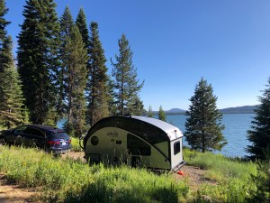 Another lesson learned: Richard actually towed Dory while we were moving sites! Granted, it was only about a hundred feet as he moved out of the dump station and into the right loop. But he did it! I was coherent enough to back her into the site, which was good cause I don’t know if he could have done that. I guess the Caravan Mover can be considered emergency backup equipment now.
 But onto the fun! Friday was kind of a bust, but Richard got to do a little riding up and down the bike path to sort of check out the area. Saturday, he did the whole loop and I followed and met up with him in spots. It’s a gorgeous lake with just the right amount of services. There is a lodge with a restaurant and store on one end, and a little pizza joint with ice cream at the other. Cell service is not so good, but if you go to the day use picnic area, there’s enough to communicate slowly. I also found that I could hit ATT 4g from the middle of the lake. And it is not at all crowded with people, so it’s kind of the perfect lake experience.
 By Saturday afternoon, I was fine and even took my boat out for a paddle. We found that there was a direct relationship between the wind and the mosquitos, and we highly preferred the former. Our site was super sweet because I could leave my kayak all set up and just tie it off on the shore. In truth, there are many, many sites in this campground that are ideal launching points. I didn’t bother to try to write down nice sites because there are honestly too many. As long as they’re waterfront, there’s a good chance you can launch from the site. And if not, there’s a boat launch in the campground too.
 Sunday Richard headed up to Crater Lake while I got in another paddle. After he’d gotten a good hour or so head start, I followed up with Bruce. Note to bikers: the ranger at the entrance kiosk did not take kindly to the idea of Richard going through, promising that his wife with the car and National Parks Annual Pass, would be following. It’s against policy and we don’t blame him for being a stickler. We’re rule followers and we get it, and ultimately he let Richard go in rather than pay the $12 fee. It makes it a lot more logistically challenging if you’re trying to SAG a bike into a park, but we’ll plan better in the future.
 The ride is a serious climb for a biker, but he lives for that. We met up at close to the top and enjoyed some views. I swear, if I had magical powers, I would make all the blue things I have exactly that shade of blue. It’s glorious and delicious and I love it.
 It goes mostly through the campground, which takes up a very long stretch of one entire side of the lake. Once you’re through all of the loops, you’re practically at the lodge. They have rooms and boat rentals, stores, and all kinds of fun things for families up there. I found the food to be so-so, but the soft serve chocolate to be top notch. #priorities
 We ended up being at the lake four nights and were treated to a marvelous sunset on the last. I took pictures while getting bit by mosquitoes. Worth it.


 We seemed to leave behind the damp, grey drizzle of western Washington as soon as we headed east. The entire look of the countryside is so different, as green gives way abruptly to gold. Temperatures are mild right now, so we’re pretty happy, having hit our intended summer weather sweet spot.
 I chose it again because of the lovely river, but forgot about the train. It’s really loud. However, neither one of us woke up last night, which either means they don’t blare their horn as loudly at night, or I am more hearing impaired than I think and Richard’s ear plugs work better than he thinks. In any case, with hearing aides out and ear plugs in, we were not woken up by the train last night. I can hear the road from the campground, but it doesn’t really detract.
 We got in around 3 and I had plenty of time to get my boat in the water while Richard got some work done. I could paddle up river until I got to the bottom of some mild rapids. So I hung around the river banks and I’m pretty sure I saw a beaver again, just like I did last time. It was a critter for sure, and I’m guessing from the size of the head that it was a beaver rather than an otter. We saw a couple swimming river bodies at sunset too, from a distance, so it was hard to make out exactly what brand of river creature they were.
 I also got to sort of test out how much of a river current I can paddle against. I spent a couple hours paddling up and drifting down, and that was very fun. In the late afternoon there was a sharp increase in the winds, so I found a non rocky place along the bank and pulled out. One thing I’m thinking seriously about is getting a set of folding wheels for the boat. Richard is being nice about meeting me and helping me carry the kayak back to the campsite, but I’m thinking I could do it on my own if it had wheels.
 We had electric hookups and cell service, so that’s always nice. The sites are newly paved and all have tree shade. There is a lot of grassy area for kids to play and it seems an awesome spot for family camping. We’ve gotten several knocks on the door for scavenger hunts, which is cute. I’m wondering if it’s all fun and games, or whether parents are needing half and half or packets of sugar and ketchup. So, rather than go shopping, they just create a scavenger hunt for their kids and see what comes back.


 We now start tracking back south and east. We planned a couple of one night stand days, just to make tracks. We then want to go back to some areas in Northern California before needing to call it a summer. Heading out of Seattle, we wanted to go along Highway 90 and found a nice little state park, just a short drive away.
 Once we were safely moving along the right road, Richard shared an idea about a biking stop he was maybe interested in trying. There is a rails to trails bike trail called the “John Wayne Pioneer Trail” aka the “Iron Horse Trail” and goes from Rattlesnake Lake, near Snoqualmie Pass, all the way to the Columbia River. We stopped at Rattlesnake Lake to get our bearings and Richard swapped out his road tires for his beefy tires. We set a point to meet up in case he wanted to bail, and he was off.
 This is a nice little state park, with sites spaced apart adequately and full hookup sites available. There is a boat launch and a sandy beach area with a playground for kids. I’d say the only downside to the park is the road noise from nearby 90.
 I have not been on my pretty blue bike very much at all. In fact, I can’t remember the last time I rode it. As a result, I have lost any tolerance I once had for sitting on a bike saddle. Like, we hadn’t even left the campground before I asked if that was really my saddle. I didn’t remember it being so hard. So we headed out with me saying, “Ow! Owowow!” either in my head or out loud. The “bike path around the lake” was not what I had in mind at all, and when we did get to the part that was by the lake, we were separated from it by railroad tracks and trees. But we could see glimpses and Richard kept pointing that out. I asked, “Is this fun?” more than once. “Yes,” he said, “So much fun.” “Ok.” Following our fun little loop, I staggered over to the lake and enjoyed the view before dinner.
 This park makes for a nice stop along the way. As a destination, I think the road noise would be a downside, but there are some hookup sites with a lake view and there is certainly an opportunity for boating and swimming. The pads are paved and level enough that we stayed hitched. We have yet to escape the PNW cloud cover. Onward and southward. We’re ready for a little heat!


 This stop was a very different kind of camping. It’s really traveling, without having to endure staying in a hotel. I had two primary goals here: see two lifelong friends, and see our favorite comedian. Both were located in Seattle and so we stayed in a KOA to the south. Coming straight off some forest service campgrounds and a national park, it ain’t much to look at as campgrounds go, and it’s probably the most sardine-packed KOA I’ve ever seen, but it also provides full hookups, laundry, and a safe place to leave Dory while we do city mice things. So it’s perfect.
 On our way, we stopped at a very special place. My friend, Anne, happens to be the granddaughter of the people who donated 500 acres of land back in the 70s in order to create a wildlife refuge. Its name is
 This is what happened when we arrived, which was probably around 2pm. As we headed toward the trams, having seen zero critters in their enclosures, we were muttering, “Now eventually you do plan to have wild animals? In your wild animal park?” The tram tour corrected the trend and we saw enough free roaming wildlife to make the driver visibly giddy. We apparently spotted 5 out of 6 of their moose (hooray!), plus herds of bison, elk, mountain goats, longhorn sheep, and plenty of deer, all up close and personal. That was fun.
 Returning to the habitats, we saw everybody, being all happy and active, and seeming not to care much whether there were humans staring at them. I could spend hours watching otters, and may have. We also witnessed some impressive bear play between two young males. Both were orphaned and not able to be released into the wild. The habitats don’t appear to have much of a barrier between the animals and spectators, causing one to really question whether one of them could clear the trench if they ever wanted to. My friend reminded me later that they are very well fed. However, she tells stories of being in the park essentially alone (a super nice perk for having cool grandparents) and coming across a pack of wolves staring her down hard. Doesn’t matter how much people explain it’s safe at that point. I highly recommend a visit to this place if you’re anywhere close to Seattle. It’s only about an hour drive away and very cool.
 The next day was devoted to being tourists with my pals. They played tour guide in a spectacular way and we had a blast. Included in the day’s itinerary was a lovely lunch at
 But wait, there’s more. That evening we had tickets to see Eddie Izzard. As a comedian, he’s hard to describe. If you know him, you get how hysterical he is and his latest show does not disappoint. In addition to being brilliant, and worldly wise, and hysterically funny, he is also a transvestite (an “executive transvestite” to be specific). Appropriately enough, the man sitting next to us was dressed very tastefully, wearing classy women’s clothes, makeup, and sporting a hair cut I could never pull off. He was beautiful and we struck up a fascinating conversation about his journey. People around us joined in and the experience gave me an uplifting feeling about people. And then of course, there’s Eddie, who can transition from a riff on what would happen if there were animals besides humans who became bat-like superheroes (“I am Bat Giraffe.” “I am Bat Crocodile.” “I am Bat Bat.”), to how to push off the destructive power of evil by doubling (not ‘re-doubling’ as he points out because that makes no sense) our own efforts to do good in the world. I so love that man.
 Saturday exhausted the country mice. Sunday was a glorious recouping day filled with: laundry, internet and blogging catch up, shopping, and route planning for the next leg of the journey.


