
Mather Campground
Another great stay in our first official National Park of this trip. I will go ahead and admit, for the record, that I was wrong about South Rim. I had developed the notion that this would be an entirely touristy place and that I would probably not want to come back. I was mostly using this as a bargaining chip for Richard to agree to the long trek to Quebec. I was mistaken. It was incredible and I would come again.
Seligman – the “birth place” (but not actually) of Route 66, with the Roadkill Cafe in the background

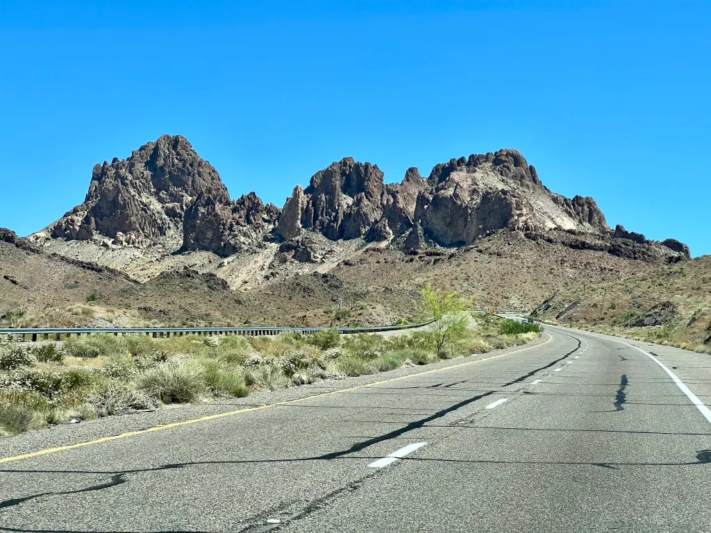
Leaving Hole in the Wall, we saw two Roadrunners, literally running across the road! That was exciting for me because I look for them all the time when we’re in the desert, and rarely do I spot one. We then headed east, with a route planned to avoid Interstate 40 after Needles. We got a super helpful heads up that the stretch between Seligman and Kingman was so full of potholes, the tow trucks couldn’t keep up with blown tires. A call to the Arizona DOT confirmed that, and we planned to take Highway 66 in order to avoid the booby traps. That was a lovely detour that I would take again, even without the poor road conditions. We were on Historic Route 66 for many miles, but it wasn’t until we saw a series of red billboards with clever little rhymes, and a final billboard with the “Burma Shave” logo, that it seemed any different than any other road. In the towns of Kingman and Seligman, however, there were all kinds of Route 66 themed restaurants, and billboards, and little stores. Seligman seems to be the hot spot for all the kitchy themed things. We stopped briefly as we went through, but didn’t really spend time diner hopping or souvenir shopping.
Route 66

We did have to hop back on 40 from Ash Fork to Williams, maybe twenty or so miles, and it was not bad in terms of road conditions. Still, I was happy to turn off and head north on the smaller highway 64 for the rest of the journey. We had no problem getting gas along the way, but I think the station just south of Hole in the Wall wins the prize for most gougingly priced. Since we knew it was going to be a long day of travel, we had gotten an early start and arrived at the campground around 4. Early starts make all the difference in the world.

There are quite a lot of Elk freely wandering the campground
Mather Campground is nicely set up, pretty much the same as many of the national park campgrounds, with little curvy pull outs for each site. Ours was on the left hand side of the loop road, so we had to pull in going the wrong direction in order for the door to open onto the picnic table. That could have made getting out difficult, but it wasn’t, because the site across from us was empty by the time we needed to leave.
Sunset over the canyon

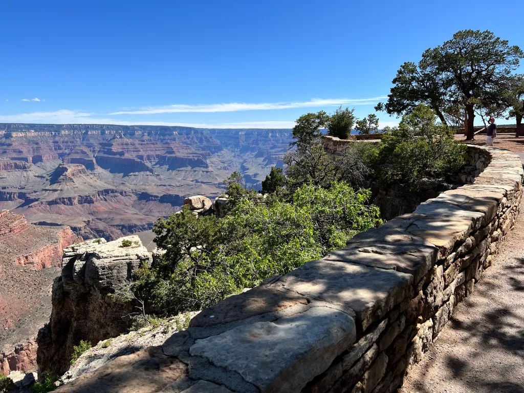
We had time after arrival for me to catch up on the blog and Richard to scout around on his bike. Then we had a nice quick dinner, with time to get over to see the rim before sunset. I hopped on my bike and Richard tried hard to lead the way, but the roads are a bit confusing around Mather Campground and the Visitor Center. We did get the hang of it all after a few days, but let’s just say, we did not take the most efficient route to the rim on our first go. We made it just in time to catch the last part of a nice sunset, and then we had to bike back in the dark because neither of us thought to bring lights. We stopped at the Market first, and wow. I can say without hesitation this was the nicest campground store I have ever seen. The produce selection alone rivals a big city grocery store. There’s pretty much nothing you can’t find there, and for us, that’s impressive (cause we’re picky).

The Rim Trail – on the section where you can bike
For our first full day in the park, Richard had arranged for an e-bike rental for me. We rode together to Bright Angel Bicycle Cafe, near the Visitor Center, locked up my bike, and got set up on a super nice rental very quickly. They gave us good advice on how to spend the day, plus detailed maps, for how to get from place to place. There are rules about where bikes can and can’t go, and roads where only shuttle buses and bikes can go. The most confusing part for us was in Grand Canyon Village, where we wanted to stop at the Verkamp’s Visitor Center. The main visitor center had annoyingly short hours of operation, and I really wanted to talk to a ranger about our planned Grand Hike the next day. Instead, we got a volunteer who gave us the super negative and extremely cautious warning speech.
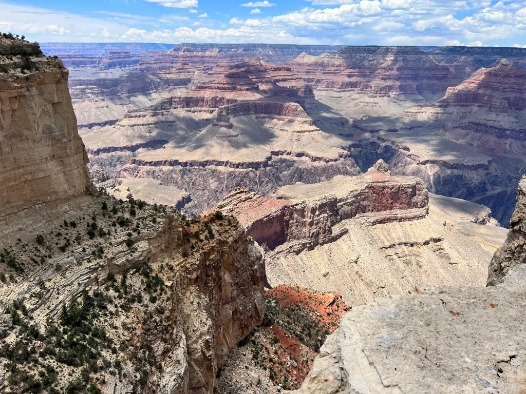
Our intended destination: Skeleton Point; right at the top of the red zone

I do know how many people die hiking the Grand Canyon every year, so none of the speech was news to me. I did know about the young woman who sadly perished just recently on one of the trails, and I did hear about how many people need rescuing because they overestimate their abilities and get caught in the heat. I knew all of that intimately and still wanted to know about doing a “Very Difficult” hike. But I wanted to talk to someone who would ask me real questions and give me real information. She told us the temperature as soon as you drop down a thousand feet was 99º, even though the sign outside the visitor center said the temperature at the bottom of the canyon was 89º. But that day was not our Grand Hike day, so we left on our bikes and found our way to the Hermit Road.

E-bike vs Richard = most fun ever
From Grand Canyon Village, all the way out to Hermit’s Rest, no cars are allowed on the road. It is an unbelievable ride. You’ve got views of the canyon all along the way, with numerous view points and named shuttle stops. Then you can actually bike the Rim Trail for a couple of good long sections too, where you are literally right on the edge. For these stretches, there are hardly any people walking the trail, so it is just spectacular. Right now, wildflowers and green bushes border the path, leading you down an unrealistically gorgeous promenade to the end.
Hermit’s Rest

The last stop on Hermit Road is a place called Hermit’s Rest. There is a nice gift shop there with bathrooms and a snack bar. You can relax there and take in the views looking down at the Colorado River, five thousand feet below. We enjoyed the sandwiches we bought at the market and then turned around to make our way back. We took our time, stopping at every viewpoint. I love e-bikes a lot. There is nothing better than hitting a hill, turning up the power, and zipping past Richard, without even breaking a sweat. Just for fun sometimes I would offer him encouragement, “You can do it!” “You’re doing great!” I knew he couldn’t catch me, so I could be a smart ass with no repercussions.

Dory scoping out the head of the South Kaibab Trail
Before returning the beloved e-bike, we went up to the other end of the road, at Yaki Point. Close to that is the start of the South Kaibab Trail. I wanted to just get a glimpse before we took it on. I can’t say doing so was reassuring, since it goes straight the hell down, right from the get go. I tried just to not think too much about it, except to worry (more) about how to take enough water. After relinquishing the e-bike and retrieving my (much slower and less comfortable) regular bike, we went back to Market Plaza. We had a very nice dinner at Yavapai Tavern, and then went back to the Market, which also cohabitates with Grand Canyon Outfitters. There we each bought an extra 3 liter hydration reservoir (water bags), so that we could totally overkill the answer to: “Are you carrying enough water?”
Starting down, down, down

We both woke at dawn. I have been worrying about this hike, and actually losing sleep over it, for weeks now. I knew that this would be the most difficult hike I have done so far and there are a thousand ways things could go horribly wrong down there. Whether it was a good idea for me to attempt totally depends on whom you ask or what you read. The weather was totally working in our favor though, and I knew Richard would end up with a serious case of FOMO if we didn’t at least try. The plan was to hike down the South Kaibab Trail and get as early a start as we could. I was pretty sure I could get to “Cedar Ridge” and back because I’ve hiked at least 1,500′ and three miles before. Richard had his eye on the next point, “Skeleton Point,” and that adds another five hundred feet, making it a six mile, two thousand foot venture. And the thing about Grand Canyon hikes is that you do the easy part first. That’s how you die.

Lovely. Thanks. That’ll calm down the nerves.
We used the shuttles to get to the trailhead, which worked flawlessly. It was lightly raining actually, so we brought a bit more gear than we were hoping to. We were each packing over a gallon of water, had lots of salty snacks, tons of extra food, and a huge bag of Halloween candy, graciously given by our wonderful neighbors, Caz and Steve. Through the heavy rain clouds crowning the entire North Rim, shone a rainbow. Definitely an auspitious start.
Rain in the canyon, but no longer on us

The trail begins immediately with steep switchbacks. Between switch backs are long stretches of steep stone steps, or stone lined pathways, until you eventually reach the first milestone: Ooh Aah Point. This is the end of the “green zone,” the “have fun” zone, the one where you’re probably going to be ok as long as it’s not hot.

My favorite picture of the trail
From there down to Cedar Point, it is almost, but not quite, as steep. Rather than switchbacks, the trail contains long plunging ramps. The steps are either made of stone, or wood, in order to prevent erosion, and maybe skidding your way to the bottom. Finally you arrive at the next stopping point, where you will find the only pit toilet between the top and the river. There is no water there anywhere on this trail. And that is the middle of the “yellow zone,” the “be careful” zone, the one where you’d better be damn sure of yourself before going any further.
The flat plateau beyond and below the prominent rock formation is our destination.

Here entered the second most important stroke of luck: Neal, the National Park Service volunteer. I was feeling good and the weather was holding a nice cool temperature. We noticed Neal immediately because he had an official patch, and a walkie talkie. If he had given me anything other than a full endorsement, I would have absolutely called it a day there. But Neal was very experienced with this trail, as well as with rescuing people who screwed up. He looked me up and down with as much subtlety as could be managed, and asked about our water. I told him I had five liters and he pondered just for a moment. Then he said how the weather was nice and cool, it was early in the day, and that ought to be enough for the both of us. I explained that, no no, the five liters was just for me; Richard eagerly shared how he still had a gallon left. Neal laughed and asked if he could have some. He said we should be just fine and “there’s no reason not to go on to Skeleton Point.” He was also going that way (with his walkie talkie that could summon helicopters). That sealed the deal.

“Oh yeah! This tree was in Treadmill Trails!”
The last section was not as steep. We both saw landmarks we recognized from a treadmill video series called “Treadmill Trails.” That was fun, and where Richard got stuck on getting to Skeleton Point. It was really spectacular on the run up to the end because you can see it from far off. It is a final long slow sweep down to a level area, a welcome relief after all the descending. And at last, you come to the edge of the plateau where you can celebrate and have some lunch. We got to the marker around ten, having started down from the top at seven thirty.
Made it! …. I mean, to the bottom…

We found Neal, happily sitting off to the left hand side of the plateau, where he told us the good views of the river were. We all sat down together and had a nice long chat, while we ate and Neal pointed out the views of interest. We learned that Phantom Ranch, the campground down at the bottom, requires a reservation thirteen months in advance, with a lottery system. There is full service food, and flush toilets, with camping for tents, or cabins. Sounds amazing, but something I am unlikely to see in person. We gave Neal some Starbursts and got ready to start the real part of the hike.

Don’t look up.
Climbing back up two thousand feet is about what you might think. Honestly, if the weather had been any hotter, I might have been really scared. But it wasn’t. And there was a gorgeous breeze with perfect blue skies after the morning rain clouds moved on. Every so often, a cloud would pass in front of the sun, and that was delightful. So it was just slow, and steady, and chunk it into parts. I stopped and ate a snack half way up to Cedar Ridge, then stopped again once I got there, and then finally again at Ooh Aah. In between, I paused, sometimes took a break when there was shade, and regularly powered up with Chex Mix or Skittles. It was an indescribable feeling to finally make it all the way to the top.
Unit powering down. Out of service. Try back later.

We made safely back to Dory where I fully powered down for a couple hours, half exhausted, half relieved. I slept like a rock that night. Richard asked me if I had “fun” and I couldn’t answer that question right away. It was hard, and scary. I felt a sense of pride and accomplishment for sure. But fun? That I couldn’t say until the following day. The circumstances were so perfect that I felt I had to try, and I am glad I did. I don’t feel a sudden impulse to go do all the canyon hikes in the world. But now that this one is in the rear view mirror, I can say I enjoyed the experience tremendously.

That was Big Deal hike for me. You could even say it was Grand.
I will say it is a giddy feeling, after over a year of calorie counting and being super careful, to be able to eat whatever the hell I wanted and know I’d earned it all. Ok sure, I had fun. Would I do it again? Ask me in year.
Total miles from Hole in the Wall: 317.9 (avoiding 40 as much as possible), 18.2 mpg, 8 hours 13 min. Site 89 no hookups, some solar (enough to keep batteries up), good service for both. Good dump, but no rinse water. No recycling in campground. Pull aside site where door would have been facing wrong side, so turned around in loop to go wrong way. Easy to pull back out, but needed the site across from us to be empty. Shuttle system in the park is awesome.


The pictures are incredible, thanks for sharing them. You did great 😊
Thank you!! 🙂
What an incredible trip down in the canyon! Thanks for this post! It brought back so many memories. Hance is named after John Hance, first settler in the Grand Canyon! Inspired by the Hance rapid! The photos are absolutely beautiful!
Oh wow! I did not know where Hance’s name came from. That is so cool!