
Very private sites between lush vegetation walls
Someone needs to figure out how to share water across regions. While the entire southwest is experiencing unprecedented drought, the northwest is getting doused in an unprecedented deluge. There must be some way to channel all this excess water to where it is needed. We think a giant funnel diverting everything to a tunnel under the Sierras would work, but maybe scientists can iterate on that idea.

Sustained raininess
We’ve been monitoring weather reports very closely and checking for flood warnings before moving from one place to another, but it looks like Yellowstone is taking a horrible pounding. Even though our reservations there are over a month away, I’m pretty sure that will be off the table. They are going to be rebuilding washed out roads for at least another year. Meanwhile, Richard is trying to keep his chin up about the bike ride he was looking forward to in the Coeur d’Alene area.

The hills are alive with future French’s.
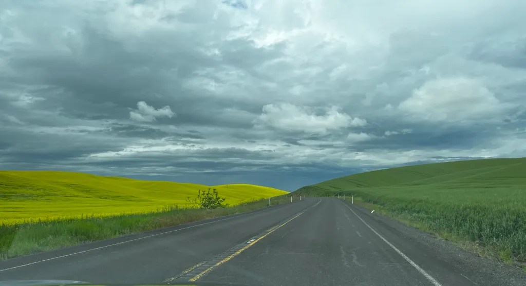
We moved from Deschutes in northern Oregon to southeastern Washington, landing in Lewis and Clark Trail State Park. The day was a rain drive, mostly following the Columbia River to the east. Eventually, we entered Washington and went through many miles of bucolic rolling farmland. The greenery was dense and regular but looked a lot like wild grassland. We Googled it and confirmed that wheat is the predominant crop in these parts, so that explains it. We clearly saw swaths of what must be mustard too, and it made quite the colorful impression.

Despite the warnings, we saw no evidence of dangerous fluff.
Pulling into the campground around 3, we saw warning signs posted about an “extreme fluff” situation. I get it that having too much Cottonwood fluff on the ground could constitute a potential fire hazard, but I really hope the direst warnings I receive in life revolve around fluff in some way from here on out.

Tiny Touchet River – it probably never sees this much action.
The campground is really nice, even in the rain, and the sites have privacy walls of tall bushes and trees between them. We relaxed and obsessively checked weather reports. I am consistent in always choosing campgrounds near water features and always make an effort to select sites closest to the water. In the middle of wall-to-wall regional flood warnings, this has its downside. We scooched back away from the little Touchet River to another open site, and later went on a hunt to find it, so that we could assess how much of a flood threat it posed. The trail going around the campground is quite overgrown, and we had a hard time getting to where we could see the river, but once found, we decided it would take a lot for that to rise far enough to impact our campsite. Still, I slept lightly and put things away enough that I figured we could make a quick hitch and go if need be. Nothing happened.

There is a pleasant little trail around the campground, but it got too swampy and had too many fallen branch obstacles for us.
In the morning, we did some regrouping. We adjusted some reservations to spend another day in Coeur d’Alene and one less day at Farragut Lake. That might time better in terms of weather for Richard’s bike ride and doesn’t impact the overall schedule. We checked in at the park we were aiming for as our next stop, to see if they were under water, and it sounded ok.
So we continue on, despite the atmospheric river, and hope for a few breaks. We’ll look at alternatives to Yellowstone a little later, but I’m not holding out hope. Maybe that park will be a post retirement adventure, like in the fall. And maybe it won’t be on fire. Traveling is hard.

This is a pretty park. I would choose this place again if I were traveling in the area.
This park is a very nice stopover location in southeastern Washington. The sites are spacious and very private. It is not too far from Walla Walla, where we gassed up and enjoyed saying “Walla Walla.” There is a historic state park across the street, but it was closed so we have no idea what is there. You can’t see the river from any of the sites, so don’t bother reserving one close by. One upside to rain is that the mosquitos we saw quickly disappeared. I’ll bet they are plentiful otherwise. I’ll bet it also gets hot and humid in the summer, and there are no hookups. So there’s that.
Total miles from Deschutes: 168.9, 18.0 mpg, 4 hours 20 min. Site 5, no hookups. Good dump for $5 and potable water. Good cell service for both. Would have been solar if not for the clouds.


Hey, you’re passing through my corner of the world, Western Montana, Philipsburg to be exact. Flathead lake might be a alternative to Yellowstone. Or go on highway 93 south to Salmon Idaho, nice drive down the river and lots of options from there. Good luck
Hi there! I was wondering if I would be near to you. We do have reservations at Flathead Lake. We have three days in July between Lewis and Clark Caverns and Grand Tetons that would have been Mammoth. What do you suggest?
Tetons and Jackson Hole
👍
Hey, You’re getting into my corner of the world. I’m in the little town of Philipsburg, Mt. Flathead Lake is a nice area or head south on highway 93 from Missoula and go to Salmon Idaho, nice drive and follow the river. Safe travels and I really enjoy your blog.
Thank you so much! I will look at Salmon Idaho. I have appreciated you following me! 🙂
I have to travel through blogs being wheelchair bound
I follow your blog too. 🙂
Flathead Lake or Salmon Idaho along the Salmon river are nice alternatives
Your yellow fields may also be canola (aka rape seed)
Good to know!