 Ok, I recognize there are a lot of pictures here. And trust me, that was after deleting most. There is just a ton to see in this national park and it is all gorgeous. I think, in fact, this may be one of my all time favorite parks, despite the fact that it was rainy and overcast the whole time. The upside of coming during the week, and being willing to hike in the rain, was that it felt like we had the place to ourselves. It wasn’t until we left on Friday that we saw how different it could be with all the people flooding in. We both agreed that it was worth the weather to get the peaceful moments.
 As we drove in, we were treated with what ended up being the best views of Mt. Rainier the whole time. This is an aptly named mountain for sure, but we didn’t know that at the view point on Highway 12. Once in the park, the clouds started moving in and we didn’t see the peak again until just before we rolled out.
 Our first stop in any national park is usually the visitor center for their informational movies and topo map models. We are truly giddy for that. The Henry Jackson Visitor Center is definitely the place to go for all the info, plus wifi. There’s a cafe, and there’s also a restaurant at the Paradise Inn. The road up from the Cougar Rock campground was windy and and upward climb, but could have been doable for Dory. Parking is challenging though with a trailer, so we unhitched and set up in the campground first.
 Richard went to the ranger talk in the campground at night and learned a great deal about the architecture in the park. Apparently, this was one of the first national parks to develop a comprehensive aesthetic plan before building all of the access points for visitors. A great deal of thought went into how to balance accessibility with maintaining the natural appearance. Bridges were specifically designed to incorporate the rocks found in the area so they’d blend in better. Facilities and roads were carefully placed so people could drive past the most beautiful features and experience the best views of the landscape. I must say, they did a really good job.
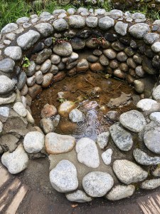 On our first full day in the park, we did several “little” hikes. I’ve decided that Richard’s specialty in life is to drag me to beautiful places and try to kill me. Individually, the hikes we did looked short, but after that day, we did somewhere between 8 and 9 miles of hiking with much of it being climbing. He is very good at his job and I was pretty fried, but we got to see some beautiful waterfalls so I must admit it was worth it. From the Cougar Rock campground, we first took the trail down to Longmire. From there, you can do an easy interpretive loop around a meadow called called “Trail of the Shadows.” Here you get to learn about how the cold springs were used to draw visitors in the early days, with the promise of a spa like, recuperative getaway. Many of the stone pools are still there and there are places where the water bubbles up out of the ground, creating a rusty colored patch of earth made of Travertine. When the springs are cold, the mineral deposits do not clump and crystalize, so it all spreads out.
 Returning to camp, we then took the trail up to Carter and Madcap Falls. This trail takes you first across the Nisqually River and then you climb upstream following the Paradise River until you come to the falls. By this time, we’d already done maybe 5 or 6 miles, so I was feeling it. Really, only the promise of a beautiful water feature can move my feet uphill like that. I didn’t say much and instead concentrated on putting one shoe in front of the other until we got to the lookout. “Yes, it’s beautiful. Fine. How far is the other ______ lookout?” The hike down was considerably easier. On our way, we noticed a long pipeline that appeared to be made out of wire bound wood. Like a long extended wine barrel. We decided that’s what that was and that there must be a wine spigot at the bottom. That would be a fitting reward for such a long day. Tragically, that was not the purpose of the pipeline and Richard found out from a ranger that it had something to do with a hydraulic power project they tried to do in the 70s but was later abandoned.
 Of special note on this day is the fact that Richard got to try out his new Rain Kilt while hiking for the first time. I’m not allowed to tease him about it anymore. He wants me to note that it was highly effective at keeping rain off his shorts and that it packs down very small. No, he does not wear pants. Ever. We got broad smiles from the few other hikers we saw, and laugh all you want, but I’ll bet you’re wondering right now if you also need a rain kilt.
The next day I suggested we drive places. We took the Stevens Canyon Road to explore the eastern side of the mountain, and sure enough, the weather was just a bit less wet. We passed by several beautiful lakes, which I’m sure are even more stunning when the clouds part and they are able to reflect the mountain. No such luck for us.
 We did get out and do some short hikes along the way. One was to Box Canyon. This is a place where there is a deep gash in the rock, with water rushing through vigorously more than one hundred feet below. Part of that trail is closed, but we got a great view and were able to go on the bridge directly above.
Another trail we did was close to the Ohanapecosh Campground. We first checked out the campground and Visitor Center there and first ascertained there is no wifi and no dump. Until we learned that, we were thinking that would be the better place to stay since the eastern side tends to be less wet that over at Cougar Rock. They do have lots of RVs in the campground, but you’d have to find somewhere else to dump.
 This is an interpretive loop called the Grove of the Patriarchs which is an easy walk about a mile long. It takes you through old growth forest and follows the emerald waters of the Ohanapecosh River before crossing over it on a suspension bridge. Here I got several more shots to add to my Richard crossing bridges photo collection. This was the one time in the park where we felt like there were lots of people. We figure this is because the trail is accessible and close to the park entrance. We do wonder if this is how the park would feel everywhere if it were a summer weekend.
 The last hike we did had the potential of being yet another attempt to kill me, but it was not bad. This was the hike out to Silver Falls Lookout. It was a little more than half a mile and ended at the most spectacular falls I’d seen. And that’s saying quite a lot given the watery nature of this park. This falls system cuts through the rock like a maze before shooting out at the bottom like an enormous faucet. The view from the bridge gives you a nice overlook of all the lower stepped terraces. There is a longer loop one can do right out of the Ohanapecosh campground, but I was quite content to do the half mile out-and-back and call it a day. Dinner that evening combined chili and a wifi check in at the visitor center up in Paradise.

With ambivalence, we packed up the next morning. On the one hand, we were both pretty done with feeling wet, plus we could see the park start to fill up with weekend throngs. On the other hand, this was an incredible park and we were sad to leave. In the morning, I walked to the bathroom at the end of our loop and noticed the clouds had cleared enough to see the mountain. I hadn’t brought my phone so I practically ran back to get it. I swear, it cannot have been five minutes before I returned to take a picture, and by that time there was a perfectly positioned “nope” cloud that had moved in, just to spite me.  The park was only temporarily mischievous and deigned to show herself fully before we said farewell.
What a beautiful park. Definitely earns the name, but if that’s what it takes to produce so many wildflowers and water features, so be it.
Total miles from Windy Point: 118.4, 16.2 mpg, 3 hours 5 min. Site C8 Cougar Rock. Flush toilets, dump, not much solar, NO cell service for either. Wifi at Jackson Visitor Center, or Wilderness Center in Longmire. Otherwise, nearest cell service is in the town of Ashford.


ummm… I had not ever heard of a rain kilt until today. Challenge him to wear it the way Scottish men do – with nothing underneath!!! I don’t like wearing long pants either, but not sure I could pull off a rain kilt without giggling the whole time.
Richard points out: he was completely dry. 😂